
The Australian startup uses edge AI to detect near misses, analyse traffic risks and help road infrastructure respond in real time.
Updated
September 3, 2026 4:08 PM
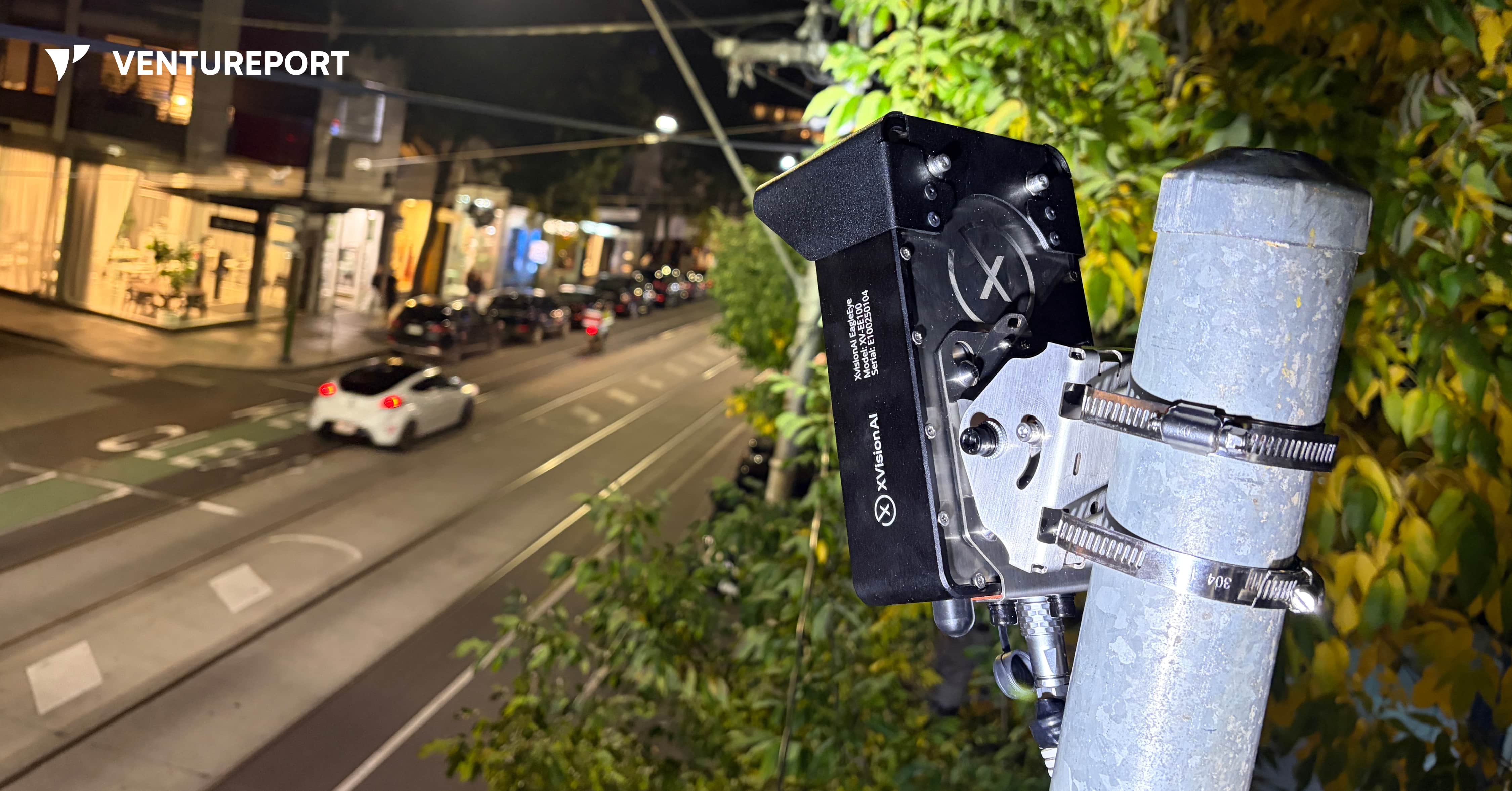
XVision’s roadside device uses computer vision to help intersections respond to traffic in real time. IMAGE: XVISION AI
According to Australian government figures, 1,326 people died on Australian roads in the 12 months to July 2026, up 0.9% from the previous 12-month period. The latest available national data also shows that road crashes led to around 36,000 hospitalised injuries. Yet many near misses are never reported.
Consider a driver turning across a pedestrian crossing without noticing someone still on the road. They miss each other by a few seconds. No one is injured, and the incident is soon forgotten. For transport authorities, however, that near miss could be an early warning of a dangerous intersection.
Australian intelligent transport startup XVision AI wants to help road authorities capture these warning signs and respond earlier. “We’re trying to create the intelligence layer for roads and infrastructure,” founder Simon Maselli says. His goal is to build smart road infrastructure that can see what is happening, understand the risks and take action when necessary.
Founded in 2023, XVision AI develops AI-powered traffic management systems for governments, transport agencies and infrastructure operators. Its technology monitors how vehicles, cyclists and pedestrians move through intersections, roads and work zones. It can count and classify road users, measure traffic speeds and queues and identify potentially dangerous interactions in real time.
Maselli came to road technology through engineering, industrial systems and testing. He previously worked on complex projects for companies including BHP Group, a major Australian multinational mining and metals corporation. He also spent time at Keppel FELS in Singapore, where he was involved in certification, approvals and scientific testing for ships.
The idea for XVision came after Maselli started his own testing company about ten years ago. One customer relied on an infrastructure system assembled from components made by several vendors. When the original provider failed to service it properly, the customer asked Maselli’s company to reproduce it.
His team succeeded, but the replacement inherited the same fundamental problem: it was large, complicated and made up of too many separate components. Maselli saw a similar pattern in road infrastructure, where one product might handle detection, another communication and additional equipment that allows for the connections between them.
“I thought there had to be a smarter way to put all those parts into one small device,” Maselli recalls. The solution also had to be easy to install without extensive roadworks, expensive components or several suppliers. That thinking eventually led to EagleEye, XVision AI’s flagship road intelligence system.
EagleEye uses two camera lenses to create a three-dimensional view of the road. Unlike an ordinary camera that only records footage, the device uses edge AI to process what it sees locally. It detects road users, follows their trajectories and analyses how they interact.
Maselli describes its functions in three stages: perception, thinking and communication. The system first identifies vehicles, pedestrians and cyclists. It then examines their speed, direction and behaviour. Finally, it can communicate with roadside infrastructure such as traffic controllers and digital signs, as well as vehicles equipped with vehicle-to-everything technology, commonly known as V2X.
For example, if a vehicle approaches a conflict area — the part of an intersection where different paths cross — at a dangerous speed, EagleEye could keep other approaches on red until it passes. If pedestrians have not finished crossing, the system could hold conflicting traffic for longer. Connected vehicles could also receive warnings about hazards or people their drivers cannot yet see.
These applications reflect Maselli’s vision for more proactive road safety. Authorities often rely on crash reports to identify dangerous locations, meaning someone may need to be injured before a problem receives attention. Short traffic surveys offer useful information, but they can miss changing road conditions and near misses that occur outside the survey period.
XVision AI aims to give traffic engineers a continuous view of movement, congestion and risk. Near-miss data could help them identify recurring conflicts, adjust signal timing or investigate an intersection before a serious collision occurs. Maselli puts the motivation simply: “One death on the road is too many.”
The company is also addressing the fragmented nature of traffic infrastructure. A single intersection may use road loops, radar, cameras, thermal sensors and analytics software from different suppliers. Bringing these systems takes time and can make upgrades expensive. Maselli estimates that a typical road upgrade in Australia can cost around AUD1.4 million and take 18 months.
EagleEye combines several of these functions inside one unit mounted on an existing pole and connects to the traffic controller. Maselli says installation only take a couple of hours, reducing the need for disruptive civil works. Although EagleEye may cost more than an individual conventional sensor, XVision argues that it can lower the overall cost by replacing several separate systems.
The software behind the hardware may be the company’s strongest commercial advantage. Customers begin with basic traffic analytics and data collection, then activate more applications on the same device. XVision has developed around ten modules, including adaptive signal control and traffic enforcement functions.
Its strongest commercial advantage is, however, the software behind the hardware. Customers begin with basic analytics and data-collection functions, then activate additional applications on the same device. XVision has developed around ten modules, including functions for adaptive signal control and traffic enforcement.
“The important thing to remember is that the hardware is only part of the business,” Maselli says. “Our core business is selling software modules.”
He calls the model “software-defined infrastructure”. Conventional road equipment is usually installed for a fixed purpose and may remain unchanged for years. XVision’s devices can receive new functions through software updates, allowing road authorities to expand their systems without repeatedly replacing roadside hardware.
The wider XVision AI platform includes two other devices. “Scout” is a smaller, solar-compatible sensor designed for quick deployment along roads and corridors. It cannot directly control traffic equipment like EagleEye, but it can collect traffic data and support wireless V2X communication. “Outpost”, on the other hand, places similar technology on a portable trailer, making it suitable for roadworks, temporary traffic studies and work zones. XVision Command brings information from these sites into one platform for monitoring, analysis and reporting.
By June 2026, Maselli said XVision had secured around 190 paid deployments across five Australian states and territories, along with six international pilots. The company has also tested its technology in Vietnam and Thailand.
Nevertheless, expanding into more markets will require more than accurate AI. Traffic enforcement and control systems must meet technical standards that differ between countries and sometimes between states. Some XVision modules, including speed enforcement, red-light enforcement and seatbelt detection, still require regulatory approval before customers can activate them.
Certification is costly and time-consuming, but it could strengthen XVision’s position once the necessary approvals are in place. Maselli describes the enforcement applications as the company’s “highest-value modules”. He estimates that certification could add AUD25 million in lifetime value across its existing deployments without installing new devices, though this remains the company’s own projection.
“Once we’re certified, we’re no longer competing in that highly competitive segment,” Maselli says. “We move into blue-ocean territory.” In practical terms, approval would allow XVision to compete in a more specialised market with fewer certified rivals.
As with any surveillance technology, privacy presents another challenge. Roadside cameras can make members of the public uncomfortable, even when they are being used for traffic analysis rather than surveillance. To address this, XVision works with customers to display signs explaining why the equipment is present. Its system also blurs video and displays it at low resolution by default, while access to identifiable, high-resolution footage requires additional authorisation.
Maselli views Australia as a proving ground for a much larger market. He sees opportunities in India, Vietnam and Thailand, where governments are investing in traffic technology. The U.S. is another target because of its larger infrastructure budgets and growing demand for connected road systems.
XVision AI still has to navigate government procurement, regulatory approval and competition from established traffic-equipment suppliers. Supporting physical devices across several countries will also be harder than expanding a cloud-based software platform.
Its advantage lies in how the technology was developed. XVision grew from years of solving practical infrastructure problems, including the fragmented system that first convinced Maselli there had to be a simpler approach. If the company succeeds, near misses that once disappeared without a trace could become the evidence road authorities need to prevent the next crash.
Keep Reading
What Overstory’s vegetation intelligence reveals about wildfire and outage risk.
Updated
January 15, 2026 8:03 PM

Aerial photograph of a green field. PHOTO: UNSPLASH
Managing vegetation around power lines has long been one of the biggest operational challenges for utilities. A single tree growing too close to electrical infrastructure can trigger outages or, in the worst cases, spark fires. With vast service territories, shifting weather patterns and limited visibility into changing landscape conditions, utilities often rely on inspections and broad wildfire-risk maps that provide only partial insight into where the most serious threats actually are.
Overstory, a company specializing in AI-powered vegetation intelligence, addresses this visibility gap with a platform that uses high-resolution satellite imagery and machine-learning models to interpret vegetation conditions in detail.Instead of assessing risk by region, terrain type or outdated maps, the system evaluates conditions tree by tree. This helps utilities identify precisely where hazards exist and which areas demand immediate intervention—critical in regions where small variations in vegetation density, fuel type or moisture levels can influence how quickly a spark might spread.
At the core of this technology is Overstory’s proprietary Fuel Detection Model, designed to identify vegetation most likely to ignite or accelerate wildfire spread. Unlike broad, publicly available fire-risk maps, the model analyzes the specific fuel conditions surrounding electrical infrastructure. By pinpointing exact locations where certain fuel types or densities create elevated risk, utilities can plan targeted wildfire-mitigation work rather than relying on sweeping, resource-heavy maintenance cycles.
This data-driven approach is reshaping how utilities structure vegetation-management programs. Having visibility into where risks are concentrated—and which trees or areas pose the highest threat—allows teams to prioritize work based on measurable evidence. For many utilities, this shift supports more efficient crew deployment, reduces unnecessary trims and builds clearer justification for preventive action. It also offers a path to strengthening grid reliability without expanding operational budgets.
Overstory’s recent US$43 million Series B funding round, led by Blume Equity with support from Energy Impact Partners and existing investors, reflects growing interest in AI tools that translate environmental data into actionable wildfire-prevention intelligence. The investment will support further development of Overstory’s risk models and help expand access to its vegetation-intelligence platform.
Yet the company’s focus remains consistent: giving utilities sharper, real-time visibility into the landscapes they manage. By converting satellite observations into clear and actionable insights, Overstory’s AI system provides a more informed foundation for decisions that impact grid safety and community resilience. In an environment where a single missed hazard can have far-reaching consequences, early and precise detection has become an essential tool for preventing wildfires before they start.