
The Australian startup uses edge AI to detect near misses, analyse traffic risks and help road infrastructure respond in real time.
Updated
September 3, 2026 4:08 PM
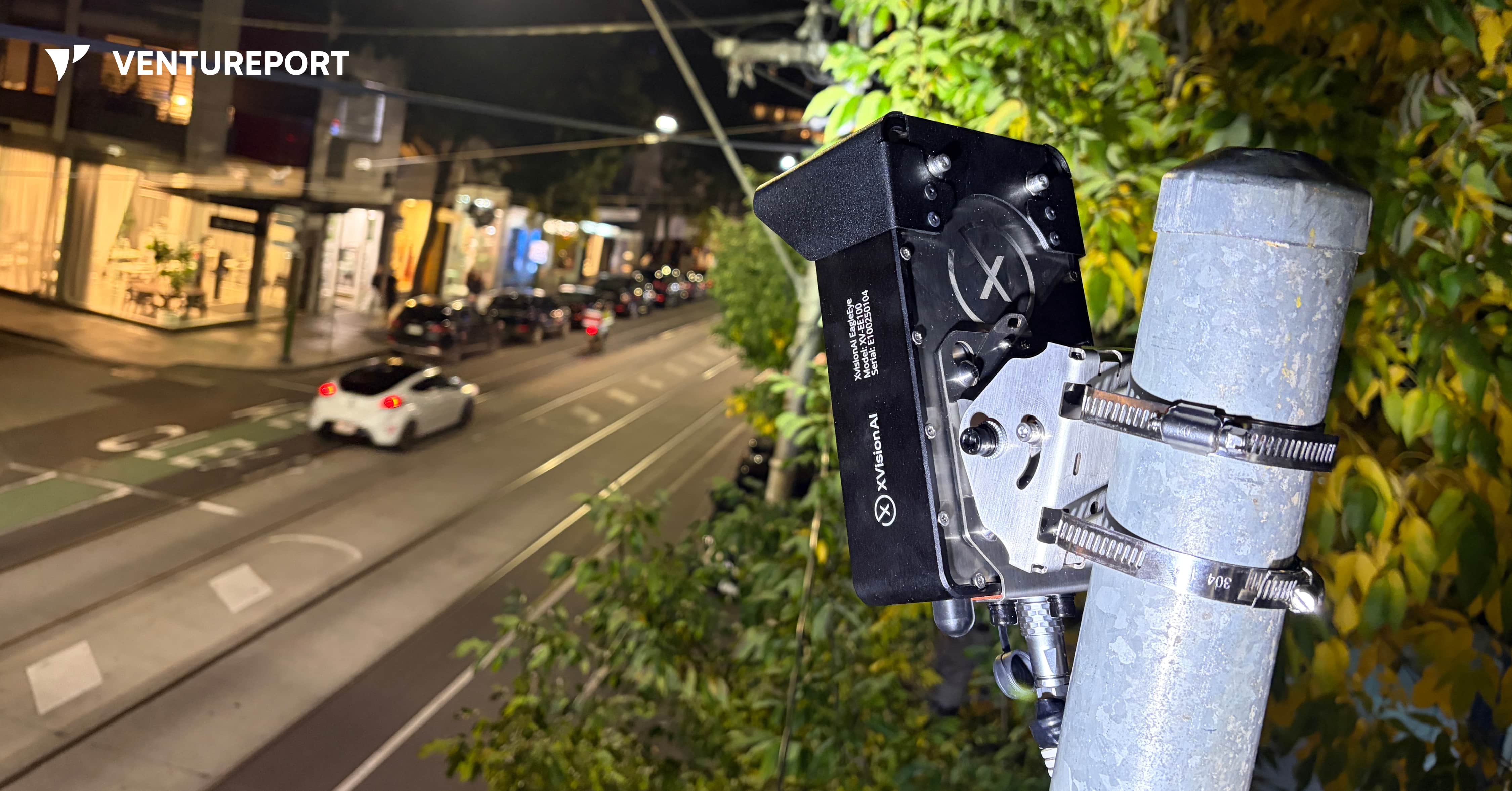
XVision’s roadside device uses computer vision to help intersections respond to traffic in real time. IMAGE: XVISION AI
According to Australian government figures, 1,326 people died on Australian roads in the 12 months to July 2026, up 0.9% from the previous 12-month period. The latest available national data also shows that road crashes led to around 36,000 hospitalised injuries. Yet many near misses are never reported.
Consider a driver turning across a pedestrian crossing without noticing someone still on the road. They miss each other by a few seconds. No one is injured, and the incident is soon forgotten. For transport authorities, however, that near miss could be an early warning of a dangerous intersection.
Australian intelligent transport startup XVision AI wants to help road authorities capture these warning signs and respond earlier. “We’re trying to create the intelligence layer for roads and infrastructure,” founder Simon Maselli says. His goal is to build smart road infrastructure that can see what is happening, understand the risks and take action when necessary.
Founded in 2023, XVision AI develops AI-powered traffic management systems for governments, transport agencies and infrastructure operators. Its technology monitors how vehicles, cyclists and pedestrians move through intersections, roads and work zones. It can count and classify road users, measure traffic speeds and queues and identify potentially dangerous interactions in real time.
Maselli came to road technology through engineering, industrial systems and testing. He previously worked on complex projects for companies including BHP Group, a major Australian multinational mining and metals corporation. He also spent time at Keppel FELS in Singapore, where he was involved in certification, approvals and scientific testing for ships.
The idea for XVision came after Maselli started his own testing company about ten years ago. One customer relied on an infrastructure system assembled from components made by several vendors. When the original provider failed to service it properly, the customer asked Maselli’s company to reproduce it.
His team succeeded, but the replacement inherited the same fundamental problem: it was large, complicated and made up of too many separate components. Maselli saw a similar pattern in road infrastructure, where one product might handle detection, another communication and additional equipment that allows for the connections between them.
“I thought there had to be a smarter way to put all those parts into one small device,” Maselli recalls. The solution also had to be easy to install without extensive roadworks, expensive components or several suppliers. That thinking eventually led to EagleEye, XVision AI’s flagship road intelligence system.
EagleEye uses two camera lenses to create a three-dimensional view of the road. Unlike an ordinary camera that only records footage, the device uses edge AI to process what it sees locally. It detects road users, follows their trajectories and analyses how they interact.
Maselli describes its functions in three stages: perception, thinking and communication. The system first identifies vehicles, pedestrians and cyclists. It then examines their speed, direction and behaviour. Finally, it can communicate with roadside infrastructure such as traffic controllers and digital signs, as well as vehicles equipped with vehicle-to-everything technology, commonly known as V2X.
For example, if a vehicle approaches a conflict area — the part of an intersection where different paths cross — at a dangerous speed, EagleEye could keep other approaches on red until it passes. If pedestrians have not finished crossing, the system could hold conflicting traffic for longer. Connected vehicles could also receive warnings about hazards or people their drivers cannot yet see.
These applications reflect Maselli’s vision for more proactive road safety. Authorities often rely on crash reports to identify dangerous locations, meaning someone may need to be injured before a problem receives attention. Short traffic surveys offer useful information, but they can miss changing road conditions and near misses that occur outside the survey period.
XVision AI aims to give traffic engineers a continuous view of movement, congestion and risk. Near-miss data could help them identify recurring conflicts, adjust signal timing or investigate an intersection before a serious collision occurs. Maselli puts the motivation simply: “One death on the road is too many.”
The company is also addressing the fragmented nature of traffic infrastructure. A single intersection may use road loops, radar, cameras, thermal sensors and analytics software from different suppliers. Bringing these systems takes time and can make upgrades expensive. Maselli estimates that a typical road upgrade in Australia can cost around AUD1.4 million and take 18 months.
EagleEye combines several of these functions inside one unit mounted on an existing pole and connects to the traffic controller. Maselli says installation only take a couple of hours, reducing the need for disruptive civil works. Although EagleEye may cost more than an individual conventional sensor, XVision argues that it can lower the overall cost by replacing several separate systems.
The software behind the hardware may be the company’s strongest commercial advantage. Customers begin with basic traffic analytics and data collection, then activate more applications on the same device. XVision has developed around ten modules, including adaptive signal control and traffic enforcement functions.
Its strongest commercial advantage is, however, the software behind the hardware. Customers begin with basic analytics and data-collection functions, then activate additional applications on the same device. XVision has developed around ten modules, including functions for adaptive signal control and traffic enforcement.
“The important thing to remember is that the hardware is only part of the business,” Maselli says. “Our core business is selling software modules.”
He calls the model “software-defined infrastructure”. Conventional road equipment is usually installed for a fixed purpose and may remain unchanged for years. XVision’s devices can receive new functions through software updates, allowing road authorities to expand their systems without repeatedly replacing roadside hardware.
The wider XVision AI platform includes two other devices. “Scout” is a smaller, solar-compatible sensor designed for quick deployment along roads and corridors. It cannot directly control traffic equipment like EagleEye, but it can collect traffic data and support wireless V2X communication. “Outpost”, on the other hand, places similar technology on a portable trailer, making it suitable for roadworks, temporary traffic studies and work zones. XVision Command brings information from these sites into one platform for monitoring, analysis and reporting.
By June 2026, Maselli said XVision had secured around 190 paid deployments across five Australian states and territories, along with six international pilots. The company has also tested its technology in Vietnam and Thailand.
Nevertheless, expanding into more markets will require more than accurate AI. Traffic enforcement and control systems must meet technical standards that differ between countries and sometimes between states. Some XVision modules, including speed enforcement, red-light enforcement and seatbelt detection, still require regulatory approval before customers can activate them.
Certification is costly and time-consuming, but it could strengthen XVision’s position once the necessary approvals are in place. Maselli describes the enforcement applications as the company’s “highest-value modules”. He estimates that certification could add AUD25 million in lifetime value across its existing deployments without installing new devices, though this remains the company’s own projection.
“Once we’re certified, we’re no longer competing in that highly competitive segment,” Maselli says. “We move into blue-ocean territory.” In practical terms, approval would allow XVision to compete in a more specialised market with fewer certified rivals.
As with any surveillance technology, privacy presents another challenge. Roadside cameras can make members of the public uncomfortable, even when they are being used for traffic analysis rather than surveillance. To address this, XVision works with customers to display signs explaining why the equipment is present. Its system also blurs video and displays it at low resolution by default, while access to identifiable, high-resolution footage requires additional authorisation.
Maselli views Australia as a proving ground for a much larger market. He sees opportunities in India, Vietnam and Thailand, where governments are investing in traffic technology. The U.S. is another target because of its larger infrastructure budgets and growing demand for connected road systems.
XVision AI still has to navigate government procurement, regulatory approval and competition from established traffic-equipment suppliers. Supporting physical devices across several countries will also be harder than expanding a cloud-based software platform.
Its advantage lies in how the technology was developed. XVision grew from years of solving practical infrastructure problems, including the fragmented system that first convinced Maselli there had to be a simpler approach. If the company succeeds, near misses that once disappeared without a trace could become the evidence road authorities need to prevent the next crash.
Keep Reading
Brains, bots and the future: Who’s really in control?
Updated
January 8, 2026 6:32 PM

Adoration and disdain, the polarised reactions for generative AI. ILLUSTRATION: YORKE YU
When British-Canadian cognitive psychologist and computer scientist Geoffrey Hinton joked that his ex-girlfriend once used ChatGPT to help her break up with him, he wasn’t exaggerating. The father of deep learning was pointing to something stranger: how machines built to mimic language have begun to mimic thought — and how even their creators no longer agree on what that means.
In that one quip — part humor, part unease — Hinton captured the paradox at the center of the world’s most important scientific divide. Artificial intelligence has moved beyond code and circuits into the realm of psychology, economics and even philosophy. Yet among those who know it best, the question has turned unexpectedly existential: what, if anything, do large language models truly understand?
Across the world’s AI labs, that question has split the community into two camps — believers and skeptics, prophets and heretics. One side sees systems like ChatGPT, Claude, and Gemini as the dawn of a new cognitive age. The other insists they’re clever parrots with no grasp of meaning, destined to plateau as soon as the data runs out. Between them stands a trillion-dollar industry built on both conviction and uncertainty.
Hinton, who spent a decade at Google refining the very neural networks that now power generative AI, has lately sounded like a man haunted by his own invention. Speaking to Scott Pelley on the CBS 60 Minutes interview aired October 8, 2023, Hinton said, “I think we're moving into a period when for the first time ever we may have things more intelligent than us.” . He said it not with triumph, but with visible worry.
Yoshua Bengio, his longtime collaborator, sees it differently. Speaking at the All In conference in Montreal, he told TIME that future AI systems "will have stronger and stronger reasoning abilities, more and more knowledge," while cautioning about ensuring they "act according to our norms". And then there’s Gary Marcus, the cognitive scientist and enduring critic, who dismisses the hype outright: “These systems don’t understand the world. They just predict the next word.”
It’s a rare moment in science when three pioneers of the same field disagree so completely — not about ethics or funding, but about the very nature of progress. And yet that disagreement now shapes how the future of AI will unfold.
In the span of just two years, large language models have gone from research curiosities to corporate cornerstones. Banks use them to summarize reports. Lawyers draft contracts with them. Pharmaceutical firms explore protein structures through them. Silicon Valley is betting that scaling these models — training them on ever-larger datasets with ever-denser computers — will eventually yield something approaching reasoning, maybe even intelligence.
It’s the “bigger is smarter” philosophy, and it has worked — so far. OpenAI’s GPT-4, Anthropic’s Claude, and Google’s Gemini have grown exponentially in capability . They can write code, explain math, outline business plans, even simulate empathy. For most users, the line between prediction and understanding has already blurred beyond meaning. Kelvin So, who is now conducting AI research in PolyU SPEED, commented , “AI scientists today are inclined to believe we have learnt a bitter lesson in the advancement from the traditional AI to the current LLM paradigm. That said, scaling law, instead of human-crafted complicated rules, is the ultimate law governing AI.”
But inside the labs, cracks are showing. Scaling models have become staggeringly expensive, and the returns are diminishing. A growing number of researchers suspect that raw scale alone cannot unlock true comprehension — that these systems are learning syntax, not semantics; imitation, not insight.
That belief fuels a quiet counter-revolution. Instead of simply piling on data and GPUs, some researchers are pursuing hybrid intelligence — systems that combine statistical learning with symbolic reasoning, causal inference, or embodied interaction with the physical world. The idea is that intelligence requires grounding — an understanding of cause, consequence, and context that no amount of text prediction can supply.
Yet the results speak for themselves. In practice, language models are already transforming industries faster than regulation can keep up. Marketing departments run on them. Customer support, logistics and finance teams depend on them. Even scientists now use them to generate hypotheses, debug code and summarize literature. For every cautionary voice, there are a dozen entrepreneurs who see this technology as a force reshaping every industry. That gap — between what these models actually are and what we hope they might become — defines this moment. It’s a time of awe and unease, where progress races ahead even as understanding lags behind.
Part of the confusion stems from how these systems work. A large language model doesn’t store facts like a database. It predicts what word is most likely to come next in a sequence, based on patterns in vast amounts of text. Behind this seemingly simple prediction mechanism lies a sophisticated architecture. The tokenizer is one of the key innovations behind modern language models. It takes text and chops it into smaller, manageable pieces the AI can understand. These pieces are then turned into numbers, giving the model a way to “read” human language. By doing this, the system can spot context and relationships between words — the building blocks of comprehension.
Inside the model, mechanisms such as multi-head attention enable the system to examine many aspects of information simultaneously, much as a human reader might track several storylines at once.
Reinforcement learning, pioneered by Richard Sutton, a professor of computing science at the University of Alberta, and Andrew Barto, Professor Emeritus at the University of Massachusetts, mimics human trial-and-error learning. The AI develops “value functions” that predict the long-term rewards of its actions. Together, these technologies enable machines to recognize patterns, make predictions and generate text that feels strikingly human — yet beneath this technical progress lies the very divide that cuts to the heart of how intelligence itself is defined.
This placement works well because it elaborates on the technical foundations after the article introduces the basic concept of how language models work, and before it transitions to discussing the emergent behaviors and the “black box problem.”
Yet at scale, that simple process begins to yield emergent behavior — reasoning, problem-solving, even flashes of creativity that surprise their creators. The result is something that looks, sounds and increasingly acts intelligent — even if no one can explain exactly why.
That opacity worries not just philosophers, but engineers. The “black box problem” — our inability to interpret how neural networks make decisions — has turned into a scientific and safety concern. If we can’t explain a model’s reasoning, can we trust it in critical systems like healthcare or defense?
Companies like Anthropic are trying to address that with “constitutional AI,” embedding human-written principles into model training to guide behavior. Others, like OpenAI, are experimenting with internal oversight teams and adversarial testing to catch dangerous or misleading outputs. But no approach yet offers real transparency. We’re effectively steering a ship whose navigation system we don’t fully understand. “We need governance frameworks that evolve as quickly as AI itself,” says Felix Cheung, Founding Chairman of RegTech Association of Hong Kong (RTAHK). “Technical safeguards alone aren't enough — transparent monitoring and clear accountability must become industry standards.”
Meanwhile, the commercial race is accelerating. Venture capital is flowing into AI startups at record speed. OpenAI’s valuation reportedly exceeds US$150 billion; Anthropic, backed by Amazon and Google, isn’t far behind. The bet is simple: that generative AI will become as indispensable to modern life as the internet itself.
And yet, not everyone is buying into that vision. The open-source movement — championed by players like Meta’s Llama, Mistral in France, and a fast-growing constellation of independent labs — argues that democratizing access is the only way to ensure both innovation and accountability. If powerful AI remains locked behind corporate walls, they warn, progress will narrow to the priorities of a few firms.
But openness cuts both ways. Publicly available models are harder to police, and their misuse — from disinformation to deepfakes — grows as easily as innovation does. Regulators are scrambling to balance risk and reward. The European Union’s AI Act is the world’s most comprehensive attempt at governance, but even it struggles to define where to draw the line between creativity and control.
This isn’t just a scientific argument anymore. It’s a geopolitical one. The United States, China, and Europe are each pursuing distinct AI strategies: Washington betting on private-sector dominance, Beijing on state-led scaling, Brussels on regulation and ethics. Behind the headlines, compute power is becoming a form of soft power. Whoever controls access to the chips, data, and infrastructure that fuel AI will control much of the digital economy.
That reality is forcing some uncomfortable math. Training frontier models already consumes energy on the scale of small nations. Data centers now rise next to hydroelectric dams and nuclear plants. Efficiency — once a technical concern — has become an economic and environmental one. As demand grows, so does the incentive to build smaller, smarter, more efficient systems. The industry’s next leap may not come from scale at all, but from constraint.
For all the noise, one truth keeps resurfacing: large language models are tools, not oracles. Their intelligence — if we can call it that — is borrowed from ours. They are trained on human text, human logic, human error. Every time a model surprises us with insight, it is, in a sense, holding up a mirror to collective intelligence.
That’s what makes this schism so fascinating. It’s not really about machines. It’s about what we believe intelligence is — pattern or principle, simulation or soul. For believers like Bengio, intelligence may simply be prediction done right. For critics like Marcus, that’s a category mistake: true understanding requires grounding in the real world, something no model trained on text can ever achieve.
The public, meanwhile, is less interested in metaphysics. To most users, these systems work — and that’s enough. They write emails, plan trips, debug spreadsheets, summarize meetings. Whether they “understand” or not feels academic. But for the scientists, that distinction remains critical, because it determines where AI might ultimately lead.
Even inside the companies building them, that tension shows OpenAI’s Sam Altman has hinted that scaling can’t continue forever. At some point, new architectures — possibly combining logic, memory, or embodied data — will be needed. DeepMind’s Demis Hassabis says something similar: intelligence, he argues, will come not just from prediction, but from interaction with the world.
It’s possible both are right. The future of AI may belong to hybrid systems — part statistical, part symbolic — that can reason across multiple modes of information: text, image, sound, action. The line between model and agent is already blurring, as LLMs gain the ability to browse the web, run code, and call external tools. The next generation won’t just answer questions; it will perform tasks.
For startups, the opportunity — and the risk — lies in that transition. The most valuable companies in this new era may not be those that build the biggest models, but those that build useful ones: specialized systems tuned for medicine, law, logistics, or finance, where reliability matters more than raw capability. The winners will understand that scale is a means, not an end.
And for society, the challenge is to decide what kind of intelligence we want to live with. If we treat these models as collaborators — imperfect, explainable, constrained — they could amplify human potential on a scale unseen since the printing press. If we chase the illusion of autonomy, they could just as easily entrench bias, confusion, and dependency.
The debate over large language models will not end in a lab. It will play out in courts, classrooms, boardrooms, and living rooms — anywhere humans and machines learn to share the same cognitive space. Whether we call that cooperation or competition will depend on how we design, deploy, and, ultimately, define these tools.
Perhaps Hinton’s offhand remark about being psychoanalyzed by his own creation wasn’t just a joke. It was an omen. AI is no longer something we use; it’s something we’re reflected in. Every model trained on our words becomes a record of who we are — our reasoning, our prejudices, our brilliance, our contradictions. The schism among scientists mirrors the one within ourselves: fascination colliding with fear, ambition tempered by doubt.
In the end, the question isn’t whether LLMs are the future. It’s whether we are ready for a future built in their image.